


| | | Tracks |
Each track point has the following information: time stamp, position, altitude and depth in meters. In the computation results there are six fields for each point: distance to next point, cumulative distance to next point, altitude in meters (a negative number means depth instead), time to next point, speed in the segment to the next point and bearing to the next point.
The edit window for tracks allows some operations on tracks that may be useful to clean uninteresting start or end segments of a track, or to compose a single track from several others. They are:
An elevation graph for a track can be plotted from the track computation window and subsequently saved as a Postscript file if there are at least 3 track points with a valid altitude field.
Creating a waypoint from a track point can be done by double clicking with the mouse left-button on a track point listed in a track window. This will open, for edition, a new waypoint having the same coordinates unless there is already a waypoint being edited. If the track is currently on the map the number of each track point together with the track name will appear in the help balloon when the cursor is over the point.
A waypoint with average coordinates can be created from a track window. Its latitude, longitude and altitude will be computed as the averages of the latitudes, longitudes and altitudes of the track points. This will be useful for obtaining more precise coordinates for a waypoint by recording a track with the receiver standing still.
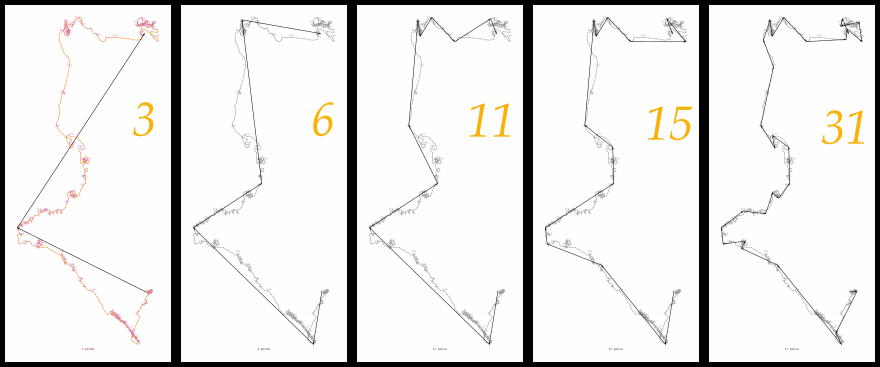
A track can be converted into a route by a simplifying algorithm that keeps a certain number of track points as waypoints of the new route.
The algorithm that was developed for this may be seen as a variant of the Douglas-Peucker algorithm for finding critical points in polylines (see, e.g.,[Heckbert and Garland, 1997] or [Li, 1995]). It starts from a straight line between the first and the last track points; if the number of points to keep is greater than 2, any point that stands furthest from the line will be retained, and the line is replaced by two new lines, those from the first to the new point and from it to the last one. This procedure is repeated always replacing one of the lines for which the distance to an intermediate point is maximum. The review of [Heckbert and Garland, 1997] describes an algorithm by Ballard and Brown (published in 1982) that seems to be very close to this one.
The sequence available here shows examples of routes with 3, 6, 11, 15 and 31 waypoints obtained from a track having 739 track points.
Although GPSMan lets the user fix the number of points to keep between 2 and the number of track points, there is a maximum number of points per route depending on the GPS receiver. It should also be noted that the time needed to find the route will increase significantly with the number of points (although keeping all the track points will take only the time to create the new waypoints).
So that a choice may be made between different numbers of points, GPSMan
may be asked to display the route and also the track on the map on
the fly. When the user clicks the Ok button, the map will be
restored, new waypoints will be created (with names of the form
ZTn, with n a 4-digit integer), and a window will be opened
for editing the route with these waypoints.
This operation will fail if there is already a route being edited; however the new waypoints will not be deleted. GPSMan will create a new group with all the new waypoints for easier access.
An animation
of the movement corresponding to a track can be
viewed in the map window (Animation button in the track
edit/show window). A control window will appear that allows for
(re-)starting, pausing, or aborting the animation, for setting
the speed, and for choosing whether the last point shown will be centred on
the map window. The default speed is that in the track: the delay between
the presentation of two consecutive points is the difference between
their time stamps. If a time stamp is not defined the default delay is
30 seconds. The state of the animation and the total (real) time since
the beginning (if defined) are displayed.
A track can be created from a route from the route window.
mig_at_ncc.up.pt, DCC-FC & LIACC,
Universidade do Porto, 2002 | | | Tracks |